Geographic
confusion continues along the border with news organisations filling in blanks
of knowledge on a ‘best guess’ stab at what might be almost right.
Tonight,
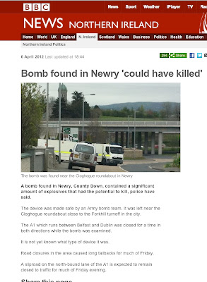
the Frontier Post antennae went up when we saw a news item on BBC about an
explosive device that ‘could have killed’ at a roundabout on the AI Dublin to
Belfast road.
The
report said that this was at ‘Newry, County Down’. However, the actual location
was at the Cloghogue roundabout.
Now
those of us who were held up – both delayed and detained – many times in the course
of our duties during the recent conflict are familiar with the location of
Cloghogue. A huge British Army checkpoint grew up there over the course of those years, eventually surmounted by
one of those big observation towers festooned with surveillance
equipment for watching and listening.
It
was not something you could have missed noticing either even driving by on the AI.
Today,
it seems, Cloghogue is just a roundabout, so anonymous in peacetime reporting that
it has shifted counties. For if somebody had done their homework before placing
it so definitively, they would find out that Cloghogue is in County Armagh.
The
confusion is hardly surprising, since everywhere prefaced by the name of Newry
is now assumed to be in County Down, although about half of the town/city
remains in Armagh where it has always been. Yet that is not the greatest
infringement of geographic confusion along the Border.
South
Armagh is included in the Newry and Mourne district for administrative purposes
and also for modern postal addresses that operate on a postcode numbers rather
than actual places on the traditional map which in rural areas was composed of
townlands.
So
Crossmaglen, served from Newry, is transferred to Down, along with Forkhill,
Camlough, Newtownhamilton and other communities. No wonder there were frequent
reports of map-reading errors down the years from squaddies who could not hope
to rely on places staying in the one spot!
 |
| The late Paddy Short, a south Armagh man who never lost his way. |
The
civil rights activist, guide, publican and wonderful raconteur Paddy Short of
Crossmaglen used to marvel about the geographic displacement caused by substituting
townland names with postal codes and signs for arbitrary road names.
One such wonder was
in his native townland of Lurgancullenboy, which had been designated as ‘Lurgan
Road, Crossmaglen, County Down’ in the official housekeeping.
Paddy laughed
heartily at that, pointing out that Lurgancullenboy was still in County Armagh
and anybody taking that road would be going off in the opposite direction of
Lurgan which, for those who do not have a good map handy, is in the north of County Armagh and quite near both County Down and County Antrim.
 |
| Built in Belfast, County Down. Sunk in Atlantic Ocean. |
In fairness, the geographic confusion it’s not just a Border problem. Anywhere north of Drogheda seems to
be a grey unknown area for many in the Dublin media, just as Belfast media can barely see
beyond Dromore – that is the one in County Down for our Tyrone followers.
Maybe
the ultimate justice in this is that current events in the Titanic Quarter are
assumed to be happening in Belfast, County Antrim, while they are actually
happening in County Down.
Such
careless navigation might even explain how somebody could have missed a big
iceberg! Surely if so many can misplace a roundabout, and an entire city or two, what
chance is there of pinpointing a big lump of frozen water on a vast and dark Atlantic Ocean?
Back
on the Border, but in the north-west this time, Traditional Unionist Voice
leader Jim Allister was in Newtownstewart last week sounding off to his vast coterie of West Tyrone followers (well, almost a dozen). His clarion cry was
that any improvements of the A5 road, which runs from Derry city to the border
at Aughnacloy, ‘will create a united Ireland by road’. Mind you, this is after
the Dublin government has withdrawn funding from the project, notwithstanding
that it would vastly improve access to and from Donegal. Now it’s just Jim Allister
ranting about a major road project for the use of people west of the Bann. Somebody must have
misplaced his map too.
There
are persistent culprits when it comes to this ‘pin in a map’ guesswork. They
needn’t think we don’t notice at the Frontier Post.

No comments:
Post a Comment